Now that we know that Aberdeen wasn’t named by any, who did name the town?
Once upon a time, before there was an Aberdeen, there was a Mechanicsville and a Hall’s Cross Roads. According to Jennings and Herrick's Map of 1858, Mechanicsville was located between Churchville and Hopewell, and, “Halls Roads,” stretched from Churchville to Havre de Grace.
Hall’s Cross Roads came into being largely as a result of Old Post Road, which was the main thoroughfare between Philadelphia and Alexandria, VA. This road, created in 1666, was straightened and reworked over the years and would eventually become, more or less, the state Route 7 we know today.
Find out what's happening in Aberdeenwith free, real-time updates from Patch.
Edward Hall was the original owner of Hall’s Park, as the tract of land was then known. It included what would be known as Hall’s Cross Roads as well as the future Aberdeen.
Baltimore County land records show that, in 1720, Hall was granted 1,140 acres. Considering the time frame, the grant would have come from the fifth Lord Baltimore, Charles Calvert, who held that title from 1715-1751.
Find out what's happening in Aberdeenwith free, real-time updates from Patch.
Given the family name and the location, Hall’s Cross Roads was a logical name for the town that evolved. The land itself would be known as Hall’s Park until it was sold in 1852.
Enter the Philadelphia, Wilmington and Baltimore Railroad in 1835. Aberdeen came into being as a direct result of the Hall’s Cross Roads railroad station.
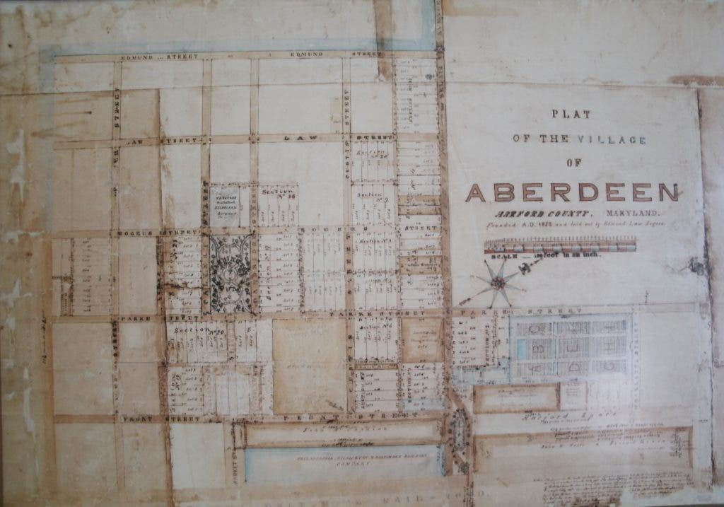
In 1852, Edmund Law Rogers (don’t those names sound familiar?), a Harvard-educated Baltimorean, was in Harford County looking for a water stop for the railroad.
Rogers “saw the opportunity to make money from the railroad due to their need for water for the steam engines that make three stops from Baltimore to Philadelphia,” according to the Review, Vol. II, No. 1.
The same document goes on to state that Rogers “anticipated the potential of the area for development.”
In 1852, Rogers “surveyed and drew up a plat with streets, lots and open spaces which seemed far ahead of the times,” according to the Aberdeen Centennial Almanac.
Thus, the Village of Aberdeen existed, at least on paper.
The name of the town comes from the Rogers’ family connection with Scotland and their dealings with the Fourth Earl of Aberdeen, George Hamilton Gordon, who went on to become Prime Minister from 1852-1855.
Rogers’ grandfather, Nicholas, went to school in Scotland, as did another, married-in family member, Dr. George Buchanan. Buchanan died without children and left the property, which would become Druid Hill (where Rogers was born), to the relatives of his wife, Eleanor Rogers, according to the Aberdeen Room Review.
Rogers named the streets after not only himself, as in Edmund Street, Law Street, and Rogers Street, but various family members as well.
Plater Street was named for Rogers’ wife, Charlotte. There was also a Charlotte Street. Custis Street was named for his great-great-grandmother Martha Dandridge Custis Washington, as well as Dandridge Street. The married-in Buchanan was commemorated with an alley named after him.
Before you consult a map, Charlotte and Dandridge Streets existed only on Rogers’ plat.
Other roads have names which have changed with time. Route 40 was known as Harford Avenue, or Broadway. Bel Air Avenue was originally called Churchville Avenue.
It wasn’t until 1855, when Rogers enlisted three partners from Baltimore to buy 600 acres of Hall’s Park, that the Village of Aberdeen began to become a reality.
Rogers “took advantage of the misfortunes of the Hall family,” who had hoped to develop the land themselves, according to the Aberdeen Room Review. There was no mention of what their misfortunes may have been.
By 1858, Aberdeen was officially on the map. Herrick's Map of 1858 shows the village right alongside the railroad tracks which would serve the town well, and help it to thrive, especially as far as the agricultural and canning industries were concerned.
It wouldn’t be until 1892 that the town would have the geography we know today. In that year, Hall’s Cross Roads, Mechanicsville, and Aberdeen were incorporated into being Aberdeen by an act of the General Assembly. The town now had the right of self-government.
Five town commissioners were elected. Among them was Charles W. Baker, of the Baker Canning family. For more information about this notable Aberdeen man, click .
Interestingly, Rogers’ original plat of the Village of Aberdeen was discovered in the attic of the James B. Baker house, by George Baker Jr., according to the Aberdeen Museum Review. The plat has been restored and is on view at .
Thus ends the myth of some Mr. Winston naming the town. How he came to be credited with the naming of the town is anyone’s guess, especially given the fact that it was public knowledge that Edmund Law Rogers designed the town, almost 20 years after station master Winston supposedly existed.
Join me next week as we explore how the Philadelphia, Wilmington and Baltimore Railroad shaped the town.